

My next book to be published is a wagon train story. I found I spent a lot of time mapping the trail -- or multiple trails, at it turned out. I also learned that most of the maps found online can offer the big picture, but they can be less than helpful when it comes to the fine details a writer needs for a historical story.
My original intent for this story was to write about the Applegate Trail
that was blazed as an alternative to reaching the Willamette Valley in
Oregon without the dangers of the northern route, particularly, rafting
down the Columbia River. Here is the big, but not historically correct picture:

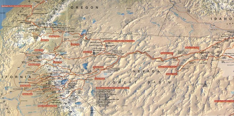
The above map of the Applegate Trail, plus several trails that led into California, is good for the casual observer who understands the United States as it currently is. Problem for historical accuracy: Most traffic to Oregon took place before the coming of the railroad in the West. Cities listed on this map like Reno and Elko did not exist before the Transcontinental Railroad. Scottbluff did not exist until a railroad came through even later in time. Salt Lake City existed, but only from July 24, 1847 on. Casper and Kearney were forts, not cities. Casper was not always an active fort during the time of pioneer trains. Carson City did not get platted until 1858 (which actually worked well for my story).
The state boundaries did not exist as we know them today. They looked more like the following:

As for Fort Hall, a trading post, not a military installation, was it in Idaho at the time most pioneers took their wagons north to Oregon Territory? No. At first, it was part of Oregon Territory. Then, in February 1859, when Oregon became a state, Idaho and Fort Hall were part of Washington Territory.

I almost goofed in my story. It takes place in 1858. I relied on the above map until I realized the date things switched. I would have been off by only a few months, but for those who know their Oregon Trail history, they would have caught it.
Then there was the issue of the details on the trails themselves. The above trail maps were a good start. Most online maps, including the ones I've included in this post, are reduced to a low dots-per-inch configuration. I found, if there was detail on the original map, most of it was lost once I saved the map to my computer and then tried to enlarge it. (They became the "Big Blur.")
I did find this map of the Applegate and California Trails that had a lot of detail, even after I saved it to my computer and enlarged it:
However, trying to find and keep track of the detail for the cutoffs and to which cities each trail led proved challenging. I found it was easier to expand the map on my computer and take snippets of the sections that interested me:

All kinds of trading posts and landmarks along the way I never heard about. Hmm...
I have pioneer ancestors who crossed the Great Plains in covered wagons. About eighteen direct ancestors qualify me for membership in the Daughters of Utah Pioneers. I am familiar with the Mormon Trail, and several landmarks along the way.
The members of the Church of Jesus Christ of Latter-day Saints who made the trek west had their "jumping off point" in either Council Bluffs, Iowa or Florence/Winter Quarters in Nebraska (near today's Omaha). They traveled the north bank of the North Platte River. Most pioneers who followed the Oregon Trail (including those bound for California) had their "jumping off point" in either Independence Missouri or later, West Point, Kansas. They followed the Blue River to the south bank of the North Platte River. They also crossed the South Platte so they could continue following the North Platte.
For part of the journey, especially west of the North Platte River, all three trails -- Oregon, California, and Mormon -- traveled the same ground.
However, when I have looked for maps online -- whether it was to track the route my own ancestors took or to learn more about one of the other trails, most were a blur. One of the best things I did when my husband and traveled B.C. -- before Covid-19 -- was I picked up paper copies of the three National Parks Service trail maps at one rest stops/visitors' centers in Wyoming.

These maps are great and have a lot of detail. However, I found I needed to use a magnifying glass to read the maps themselves. I found it easier to take a close-up snapshot of the section that interested me with my cell phone, send it to my computer, and expand it to use for reference. (Trust me, the digital copies I found online someone else already provided mostly fit into the "Big Blur" category.)
River maps that I could actually read and that included more than the major-major waterways can be harder to find than hen's teeth. However, they can be invaluable. Any thought I could use Google Maps to help me with rivers was dispelled by my research efforts years ago. Topographical view helps some, but I found I was better off finding maps like this:

The following is my BIG SECRET to mapping the trail -- almost any trail of note. Dig out the old paper maps--probably the older, the better. Triple-A maps are great. I've also picked up some maps produced by individual states they make available for tourism purposes.

Hubby and I use GPS with the best of them, but we always like to have paper maps along on our trips so we can see the BIG PICTURE. For years, I enjoyed seeing how close we traveled to some of the trails. On the paper maps, they are faint. They don't stand out like the major highways and cities. However, they are there.
For this novel, I dragged out all my old maps of the states where I planned many of my story scenes. Fort Hall in southern Idaho was a big one, because, unless a train took a cutoff, most pioneers on the Oregon, California, and Applegate Trails passed through Fort Hall. There were several trails that led into the fort. Several trails branched off once pioneers traveled west. I used my yellow highlighter to help the trails stand out from the modern streets, and took a picture with my cell camera:

Wagons Ho! I knew which direction my wagons would roll.

My next book is part of the Prairie Roses Collection and titled Pearl. It is currently on pre-order. You may find the purchase link by CLICKING HERE.
No comments:
Post a Comment