Showing posts with label California. Show all posts

Saturday, April 18, 2026

120th Anniversary of the 1906 San Francisco Earthquake by Zina Abbott


Today, April 18, 2026, is the 120th anniversary of an event that is considered one of the deadliest natural disasters to strike California—the 1906 San Francisco Earthquake. 

Map of destroyed section San Francisco, 1906

This earthquake began on a Wednesday morning at 5:12a.m. local time when many were still in bed and others were starting to prepare for their workday. The main shaking lasted forty to sixty seconds—long for an earthquake in this state. Between the destruction to buildings caused by the quake itself and the fires that followed, over eighty percent of San Francisco was destroyed, and 200,000 people were left homeless. 3,000 people perished.

California is known for its earthquakes. I have lived through several, including one in February of 1971 when I lived in Santa Monica, one in November of 1988 when I was visiting family in Orange County (my infamous “rocking sideways toilet” tale), and the well-known October 1989 Loma Prieta earthquake which interrupted the World Series in Oakland and collapsed two major sections of San Francisco Bay Area freeway. I felt it where I lived over one-hundred miles to the southeast while sitting in my car at an intersection waiting for the light to change. The quake was strong enough that I suffered motion sickness before it ended. That one was 6.9 on the Richter Scale at its epicenter in the Santa Cruz Mountains just south of the San Francisco Bay area.


The Richter Scale did not exist until 1935. However, from the geological studies performed at the time, it is estimated that the 1906 San Francisco Earthquake was about 7.9 on the Richter Scale, with a rupture about 296 miles in length along the San Andreas fault. The epicenter was just south of San Francisco.


Waiting in a provisions line

Many affected residents who were able, dressed as quickly as they could in their best. However, because they feared the aftershocks might cause additional damage and trap them inside their buildings, few gathered many of their belongings to take with them as they fled their homes.

Below is a pictorial history of this earthquake.

Damage to homes:


Rescuing people from ruins


Houses on Howard St. (Now S. Van Ness) near 17th Street

 Damage to roads and infrastructure:

Overturned locomotive

Fissure in street

Union Street streetcar line damage

Damage to the Summit Tunnel shows how far the ground shifted

Road damage to Union Street


 Fires started as a result of the earthquake:

Sacramento Street. With nowhere to go, many residents in shock watched the fires approach, moving back as the flames grew closer.

Many structures that survived the earthquake fell to the flames


Firefighters fought the flames

 
Soldiers were called in to maintain order and guard banks. A few were caught looting.


Winchester Hotel burns after the earthquake. The Hearst Building (left) was dynamited to use as a fire break between the fire and the rest of the city.

The fire marshal ordered several buildings torn down to stop the fires.

Chinatown was destroyed

Refugees:


Food was sent from surrounding cities

Food lines


Food stored at Moulder Warehouse

Food received for Moulder Warehouse

Street kitchens


Refugees gathered at the Dewey Monument

After the destruction ends:

Post and Grant Avenue, looking NE

Observatory in ruins

View from Kearny Street

Market Street

Refugee housing:

Many San Franciscans crowded the ferries to cross the bay to Oakland, where structures still stood and the telegraph was still available. 

For a silent movie of San Franciscans riding the ferry to Oakland, which was filmed at the time, please click on the link:

https://en.wikipedia.org/wiki/File:San_Francisco_earthquake_and_fire,_April_18,_1906.webm

For those who stayed, temporary housing was provided.

Jefferson Street Refugee Camp

1 of 11 refugee shack camps

Refugee cottages preserved in Presidio Park

Refugee housing

 Rebuilding: 

Cleaning bricks

 
Clearing away debris

This as a disaster known across the nation, and one to which the nation responded with support as the city rebuilt.


If you are still with me, my upcoming release is dated between 1903 and 1908. My hero grew up in turn-of-the-century San Francisco, and returns to check on family once he learns of the earthquake.


Ardith Yosemite Bride is scheduled for release on May 6, 2026. To find the book description and pre-order link, please CLICK HERE


Sources:

Wikipedia

Wikimedia Commons 

Wednesday, September 25, 2024

Shooting Affray at Turnback Creek by Zina Abbott


When I first started research for my upcoming book, and sought a logical location within Tuolumne County close to where logging in the high Sierra Nevada Mountains took place in the 1800s. I looked at Tuolumne City. For a town that never was very large, it has some interesting history.

To include the following historical event in 1858 that had profound effect on Elizabeth’s life, The California gold rush—although it had switched from placer mining to other forms—was still going strong. As the discovery of gold embedded in quartz led to underground mines—particularly in the East Belt near Turnback Creek—lumber became an important commodity. That provided my opportunity to include my “mountain man” lumberjack in a situation he later wished he had avoided.


There are several retellings of this event—most placing it in 1857. However, I will allow the newspaper account tell the story. This is taken from the January 20, 1858 edition of the Daily Alta Californian. The original story came from the Sonora Herald, Tuolumne County’s local newspaper. Unfortunately, these years of the Herald were not available on the California Digitized Newspaper Collection.

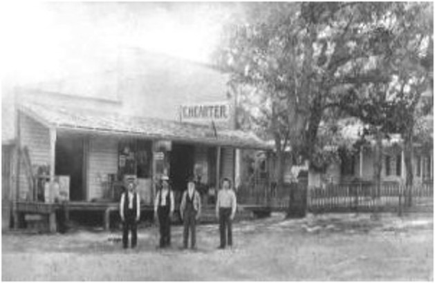
Carter's store

I will say at this point that all the local historians give the location of this meeting as Carter’s store, not Robinson’s store. This comes from more than one history written local historians.


It is known that C.H. Carter started his retail business by the Long Gulch mining area. Once he learned of the richness of the gold found in the Eureka Quartz Mine in northeast Summersville, he packed up his store and moved next to the mine. Mr. Baker, a docent at the Tuolumne Memorial Historical Museum, and a direct descendent of one of the earlier Tuolumne City families, supports the view it was Carter’s store. As he pointed out, “There just wasn’t very much in his area at that time.”

In addition, I checked newspaper articles and the 1860 and 1850 Census reports. I found no listings for a Robinson who was a merchant.


I based several chapters in my Wyatt’s New Bride, which is available as of September 26, 2024, on this incident. Although Wyatt is a fictional character, I included all of the names in this article in my story.

Here is the book description:

     Wyatt Holt gave up searching for gold. Instead, he found work as a lumberjack to satisfy the demand for timber supports in the new Tuolumne County quartz mines and lumber for the nearby towns.  He is tired of sharing barracks-style quarters with other men. With more men bringing families to the logging camps and living in company-provided cabins, he begins his search for a wife. Guided by the most unlikely of matchmakers, he corresponds with, and then sends for, a bride.

     Following the murder of her husband, to provide for herself and her young daughter, Rosalie Barker turns her home into a boardinghouse for the local gold miners. As the two-year anniversary of her late husband’s death approaches, on the night of a miner’s meeting, three of her boarders and two strangers—one seriously wounded—enter her home just as she prepares to bar the door. They beg her to care for the unconscious man. She had not been able to help her late husband. Can she keep this man alive long enough for the doctor in Sonora ten miles away to brave winter weather, swollen creeks, and bad roads to arrive and take over?

     Between being shot during a meeting gone bad, no longer able to support the bride he sent for, and uncertain if he will heal well enough to work again as a lumberjack, is there is any hope for a loving wife and family in Wyatt’s future?


To find the purchase link for Wyatt’s New Bride, please CLICK HERE


Sources:

https://sierranevadageotourism.org/entries/summersville-now-tuolumne-no-407-california-historical-landmark/e0f91d76-82fa-44f6-9736-5f4c51da5a43

California Digital Newspaper Collection; https://cdnc.ucr.edu/

https://tchistory.org/out-to-tuolumne/

https://tuolumnemuseum.wordpress.com/our-rich-history/

Friday, June 16, 2023

Tulare Lake- It's B-a-a-ck! by Zina Abbott


When I began research on my Mail-Order Mama book about two years ago, I decided to set the story in Sonora, California, where I recently had visited to do some research. One of the elements of this series was that the characters were to arrive at their destination by stagecoach. Even though I set my story in 1885, after railroad tracks reached many localities—including in California—stagecoach travel to Sonora was no issue. The train did not arrive there until 1899.


I found a great map that showed stagecoach routes throughout California from the 1850s to 1860s. Still helpful, since many stagecoach routes in the foothills and mountains still existed in later years. However, what really drew my attention was the big blue lake at the south end of San Joaquin Valley. I have lived in San Joaquin Valley for over fifty years, and I knew of no lake in that location. Curiosity piqued, I began my research.


That big blue dot was Tulare Lake, the largest lake by surface dimension west of the Mississippi River—larger than the Great Salt Lake or Lake Tahoe. It was the second-largest freshwater lake entirely in the United States based upon surface area.


Tulare Lake was at one time part of Lake Corcoran, which covered the Central Valley of California. 600,000 years ago. Although it is not known how, a new outlet formed in the present-day San Francisco Bay, which rapidly carving an outlet through Carquinez Strait. This drained the lake, leaving the Buena Vista Lake, Kern Lake, and Tulare Lakes as remnants.

1772 Southern San Joaquin Valley showing Tulare Lake

In 1773, Commandant Tagus, an Emissary for the Spanish Governor and the first white man to view the lake, named it "Los Tules." In 1825, the lake became public knowledge when the legendary Jedediah Smith led the first band of white settlers into the San Joaquin Valley.


 It was also called La Laguna de los Tulares by Spanish explorers, and covered more than 1,200 square miles. The Spanish word tulare refers to a field of tule rush, which aptly described the lake. This section of the southern San Joaquin Valley was the lowest in elevation. It was also the terminus of the Tule, Kaweah, Kings and Kern rivers.

Each spring, the area was transformed into a marsh full of tule elk and antelope, honkers, gray, and Canadian geese. Yokut hunters fished for salmon, perch and sturgeon using rafts and canoes made from the thick tule reeds. The women waded far into the water to dig for clams and mussels.

Riverboat Alta stranded on Tulare Lake

The lake was so bountiful that white settlers named the area Mussel Slough. In the 1870s, commercial fishermen went on the lake in schooners and steamboats to catch terrapin turtles, which were served as delicacies in San Francisco restaurants.

Shows early irrigation plans
 

Canals built to serve more and more agriculture affected the flow of the rivers so that Tulare Lake gradually grew smaller and, at times, dried up. Water was also diverted for municipal use. As the lakebed dried up, it was converted to agricultural uses. Canals and dams were built in an effort to keep it that way.

1854 California map by John C. Fremont shows Tulare Lake

However, in years of heavy rainfall, and heavy snowfall in the Sierra Nevada Mountains to the east, the lake reappears. In spite of multiple dams and reservoirs in the mountains and foothills, and diversion canals to funnel the water away from developed farmland, Tulare Lake reappears. 2023 has been one of those years. The Boswell Company, the biggest farming operation in the world, lost thousands of acres of crops to this year’s flood. I recall news reports a couple of months ago telling of dairy farmers moving 7,000 head of cattle within two days to save them from the flood. Even last night’s news—months after the worst of the flooding—featured houses sitting in the middle of the lake with water about four feet up the front doors and windows. Tulare County has allocated money to buy their own air boat instead of relying on those loaned by Pacific Gas and Electric, the local utility.

Tulare Lake Expedition before 1880

In the past, when there has been extensive flooding to the point Tulare Lake reemerged, it took a year or more—in some cases, close to two years—for the lake water to recede so the farmland could be reclaimed. This is one of those years.

Tulare Lake – it’s b-a-a- ck!


In September, I will be publishing a new book set in Sonora, California, titled A Watchman for Willow. It is part of the Mail Order Papa series, and will be a companion book to my Mail-Order Mama book, A Lawyer for Linton.

To find the book description and purchase options for A Lawyer for Linton, please CLICK HERE


A Watchman for Willow is currently on pre-order. To find the book description and pre-order purchase link, please CLICK HERE


Sources:

https://www.tularehistoricalmuseum.org/post/tulare-lake

https://en.wikipedia.org/wiki/Tulare_Lake#

https://www.latimes.com/archives/la-xpm-1997-02-13-mn-28291-story.html